


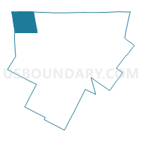
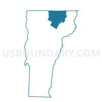
Jay Voting District, Orleans County, Vermont
About
Outline

Summary
| Unique Area Identifier | 680863 |
| Name | Jay Voting District |
| County | Orleans County |
| State | Vermont |
| Area (square miles) | 33.97 |
| Land Area (square miles) | 33.92 |
| Water Area (square miles) | 0.05 |
| % of Land Area | 99.86 |
| % of Water Area | 0.14 |
| Latitude of the Internal Point | 44.95692260 |
| Longtitude of the Internal Point | -72.50752250 |
Maps

Graphs
Select a template below for downloading or customizing gragh for Jay Voting District, Orleans County, Vermont


Neighbors
Neighoring Voting District (by Name) Neighboring Voting District on the Map
- Richford Voting District, Franklin County, VT
- Troy Voting District, Orleans County, VT
- Westfield Voting District, Orleans County, VT
Top 10 Neighboring County Subdivision (by Population) Neighboring County Subdivision on the Map
- Richford town, Franklin County, VT (2,308)
- Troy town, Orleans County, VT (1,662)
- Westfield town, Orleans County, VT (536)
- Jay town, Orleans County, VT (521)